The next hours, according to Italian meteorologists, will find Italy in the grip of a cyclone, bringing cold weather and severe conditions to many regions.
Frozen air masses from the North Pole, specifically from the distant stretches of the Arctic Circle, are moving towards the country, where a further and significant deterioration is expected within the next 24 hours. This will be due to the formation of a well-structured cyclonic system, ready to generate highly turbulent weather conditions in many areas of Italy.
Frozen air masses from the North Pole, specifically from the distant stretches of the Arctic Circle, are moving towards the country, where a further and significant deterioration is expected within the next 24 hours. This will be due to the formation of a well-structured cyclonic system, ready to generate highly turbulent weather conditions in many areas of Italy.
HEAVY RAIN AND SNOW EVEN IN LOWLAND AREAS
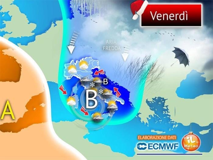
Tomorrow, Friday, the weather will be characterized by scattered rain, initially concentrated in northeastern Italy but quickly spreading to central and southern regions, with particular intensity along the central Adriatic and the southern Tyrrhenian areas. In these regions, thunderstorms accompanied by intense atmospheric instability are not ruled out.
The invasion of cold air masses, driven by the cyclone, will lead to a further drop in temperatures, favoring the return of snow in various areas. Specifically, snowfall is expected in Marche, Abruzzo, Molise, and the inland areas of Lazio and Campania, with flakes reaching altitudes as low as 500-600 meters. In the mountainous areas of the South, snow will be more abundant at higher altitudes.

GALE-FORCE WINDS
The significant pressure gradient, created by the strengthening of an anticyclone over Western Europe and the cyclone positioned over the southern Tyrrhenian, will result in gale-force winds across many regions.
Mistral gusts will reach impressive speeds, exceeding 100 km/h along the western coasts of Sardinia and Sicily. In these areas, sea conditions will be particularly rough, with waves as high as 6-7 meters, capable of causing significant coastal damage, especially in the northern and western parts of Sardinia.
In the Adriatic, northerly winds will intensify, primarily affecting central regions and contributing to a sharp drop in temperatures.
By evening, the weather conditions will stabilize definitively in the northern regions, while strong instability will persist over the central Adriatic and the Tyrrhenian regions of the South, with the snowline potentially dropping further to around 900-1000 meters.